1. Summary
in 1598 the common arable, pasture and meadow of Great Crakehall (with the exception of the Ings) was enclosed and divided between the tenants by a Special Commission from the Exchequer Court, procured by the principal yeoman farmers of the village.Each farm and cottage was allotted a consolidated block of arable land in one of the common fields, and a proportional area of pasture in place of beastgates in the common pastures.
Soon afterwards, the Hollowmoor common in Little Crakehall was also enclosed, but the farmers there would not agree to wholesale enclosure of the arable fields. This nevertheless took place, piecemeal, over the next 50 years.
Enclosure allowed the farmers more flexibility in the way they cultivated their land. One particular result was an increase in the amount of land temporarily laid down to grass.
In the 18th century the landowners consolidated some of the holdings into large farms and built new farmhouses in the centre of them - for example High Scroggs, Mudfield and West Pasture.
Other substantial changes took place over the years. The Hagg and Burstall woods were clear felled to create more grazing land in the 17th century. Late in the 18th century plans were made to properly drain the Ings to prevent winter flooding; although long put off, this was finally done early in the 19th century. The Ings were finally enclosed by Act of Parliament in 1833.
2. The enclosure of Great Crakehall
Late in Queen Elizabeth's reign the inhabitants of Crakehall took a step that was to change their lives, and the village landscape, for ever. In 1596 they had seen the open fields of Bedale and Aiskew enclosed, and in 1598 they petitioned the Court of Exchequer for permission to enclose the common fields of the Great Crakehall. As tenants of Queen Elizabeth I they asked her to appoint "Special Commissioners" to:A survey of the village and its fields dated about 1602, in the Public Record Office in London, was made before the farmers had divided up their allotments, and the information in it allows us to draw up the picture of the Great Crakehall open fields on the brink of enclosure, that is shown in Map 1.You can read a transcript of the complete document HERE
The farmers were fortunate in being able to enlist the support of Sir Timothy Whittingham, a notable and influential County Durham JP. He had a personal interest as stepfather and guardian of Thomas Jackson of Cowling Hall, whose family were customary tenants of a farm in Crakehall that had belonged to Coverham Abbey. He was also a keen agricultural improver. He had already made private agreements to settle the boundary between Cowling and Crakehall in the Scroggs pasture in 1593, and between Cowling and Burrel in Burrel Moor in 1597.
In response to the petition of Sir Timothy and the other tenants of Crakehall, the Queen appointed as her committee of enquiry Sir Ralph Lawson of Brough, near Catterick, Adam Middleham, the Steward of Middleham Lordship, John Girlington of Hackforth and Sir Talbot Bowes of Aske Hall, who was later MP for Richmond. They made a thorough survey of what land and houses the tenants of Crakehall had, then assigned each of them a few large pieces of land in the Scroggs pasture, the common arable fields, and the Low Pasture, calculated to be reasonable replacements for their previous strips in the open arable fields and for their stints in the common pastures. Because they were shared with other villages, NoMans Moor and the Ings meadow were excluded from the division and remained common land. The Commission's allotment to William Jackson, one of the most important yeoman farmers in the village, illustrates their approach (one rood was a quarter of an acre):
Item: we have laid out to the said Wm.Jackson in a place called Dobraynes within the Scrogg Feild of Crackall 48a.
Item: in a place called Hiehoe in the Gill Feild 22a 2roods.
Item: in a place called Garthende in the East Feild 8a 2r.
Item: in the Low Pasture 35a.
Item: in the Scrogg 5a.
Item: in Inglow Rayne 1a 2r.
Item: in the Evers to the said Wm. Jackson for his parte of the said wastes to the same belonginge 7a.
Item the said Wm. Jackson hath to his farme belonginge 9a 3r of medowe by estimacon lieing in the Ings which is in comon with the lordships of West Cracall and Langthorne, yet severed and knowen by merkes and dowles.
Following the allotment of land the Commissioners appointed some local worthies to supervise the surveying and marking out of "waies, gaitesteads, stiles and hedges" to the new fields. The tenants agreed to share the costs of the work, and of settling any legal disputes that might arise as the result of the enclosure.
The farmers benefitted from the enclosure in two main ways. Their land was now in compact holdings instead of scattered in small strips all over the common fields; tenants with only one farm received a single block of arable in one of the old common fields. Also, they now had the option of increasing their grazing land by putting down some arable to grass, just as they had already done in their "awncient closes". For the first time they could see their farms whole and independent. It must have been an enormous step, and it was probably because of its novelty that the Commissioners created a very strange anomaly. The case of William Jackson again illustrates this clearly. He was tenant of a total of five farms and two cottages in the village. One farm and a cottage had been part of Coverham Abbey's property while the rest was part of the lordship of Middleham. The Crown continued to regard these as completely separate estates and indeed sold them separately in the next 25 years, yet where a farmer was tenant of both Middleham and Coverham farms the enclosure commissioners had not allocated land separately to the two groups of farms. This caused enormous problems for the Crown when they wanted to sell the Coverham and Middleham parts of the village separately. While everyone knew which houses and cottages had belonged to the Abbey, no-one knew which bits of the newly allotted land should be assigned to each! The frustrated surveyors who valued the village before the sale of the lordship of Middleham's share in 1624 wrote about the Jackson farms:
They were so confused that they had named the abbey incorrectly and had confused Jackson's Coverham and Middleham holdings!
Presumably the approach taken by the Commissioners was to divide the allocated land into smaller fields and allot these proportionately to the different farms, but exactly how this was agreed and carried out is far from clear.
The method of allocating the enclosed lands also tempted the big farmers like William Jackson, to 'asset strip' the cottages in their tenure of their allocated pasture and meadow and incorporate it into their bigger farms, providing much-needed increases in their grazing land, but at the expense of the sub-tenants of the cottages. In Queen Elizabeth's time this was illegal, and soon after enclosure we find several substantial Crakehall yeomen, including William Jackson, appearing at the Quarter Sessions court in Bedale and Richmond to answer that "he hath decayed one husbandry and made it a cottage" or for "erecting a cottage, not laying any land to it".
The enclosure stirred up a few local feuds too, to such an extent that litigation in the Exchequer Court held up completion of the process for two years. The first of these disputes was, predictably, with the Metcalfe family, who had been the target of local hostility on and off for the previous seventy years. As mentioned earlier, in the early part of the 16th century Katherine Metcalfe of Bellerby had taken a lease of the old demesne sheep pasture at Crakehall Cote and had also rented the whole of the common pasture called Vyvers, compensating the unhappy villagers by allowing them her part of the Scroggs. The Vyvers was still occupied by Katherine's grandson, Miles Metcalfe, in 1598, and in anticipation of the forthcoming enclosure Metcalfe fenced it in and claimed it as his own. The villagers foresaw that they could lose their rights to both Vyvers and the Metcalfes' part of the Scroggs on enclosure. They were so angry at Metcalfe's action that "they did enter into the said ground called vyvers and did put in their beasts and did cut down and carry away the hedges".
Presented with this fait accompli Metcalfe appealed to the enclosure commissioners to delay the enclosure process until he could produce documentary proof of his right to Vyvers, which he claimed to have in the family archives at Louth in Lincolnshire. However, the documents never turned up and eventually the Commissioners divided Vyvers (called Evers in the enclosure award) amongst the village farmers. The other delay in the enclosure was caused by the personal problems of another tenant, Adam Clapham, who refused to agree to the enclosure. A relative had chosen this time to dispute Adam's right to one of his farms and this involved him in expensive litigation in the Court of Chancery. It was perhaps understandable that he wanted nothing to do with the expense and legal risks of enclosure. His brother John, whose own tenancy in Crakehall Adam actually farmed:
This case also shows that on the whole the enclosure was worked out amicably between the tenants and the commissioners.
3. Great Crakehall after enclosure
Although the enclosure process must have been expensive for the farmers, particularly the fencing and hedging needed over several years to enclose their individual fields, it nevertheless increased the values of their farms considerably. The case of Thomas Jackson's farm illustrates this well. His traditional "fee farm rent" to the Crown for his farm, which before enclosure consisted of a farmhouse, 27 acres of arable, 4 acres of meadow and grazing for 6 beasts, was £2-4s-4d a year. This was absurdly low: he was able to sub-let it to Henry Mason for £12 a year. After enclosure Henry's widow occupied the house and garth for 10s a year, Jackson let 6 acres of the land to Richard Vyttie for £2-10s a year, and the rest of the farm to another farmer at £15-13s-4d, giving a 50% increase in income. By 1624 the same farm was valued at £21-8s-6d per annum.
In 1624, after the Coverham Abbey property in the village had been sold to Sir Richard Theakston, and in preparation for the sale of the rest of the manor, the Crown carried out a great survey of the village and its fields, together with Rand Grange. Aaron Rathbone, the surveyor, also made maps, and the one for Rand Grange survives in the Beresford Peirse archives, though the one for Crakehall seems to have been lost. The written survey was discovered a few years ago amongst the Crakehall parish records and is now in the North Yorkshire Record Office. From this we can see the way the farmers gradually divided up into conveniently sized fields ("closes") the large pieces of land allotted to them by the Commissioners. Each farmer's land is described field by field, with an indication of where each field was situated. By the time the survey and valuation was made in 1624, most of the field pattern we see today was already established. Only a few undivided pieces of pasture remained - notably Thomas Jackson's parts of the old Scroggs pasture, various parts of Low Pasture, and some parts of Jane Jackson's (William Jackson's widow) allocation in the Gill and East Fields, which had been converted into large pasture fields.
Agriculture in Tudor and Stuart times
Probate inventories, the inventories of the household goods and farm stock made when a villager died, give a good idea of the sort of farming carried on between 1580 and 1700. An example is shown HERE. For many years before and after enclosure the pattern remained the same. On average a farmer had a team of four draught oxen for ploughing, about ten dairy cows, between 15 and 30 sheep, and a few pigs and poultry. Before enclosure grazing was limited, and the most obvious change in the way the farmers used their land after enclosure was the way they laid down some of the old arable land to grass. This new, good quality grassland supported better dairy yields and contributed to the fame of the area for butter and cheese. At the same time the old Scroggs pasture was being improved. At enclosure it still had areas of bracken and scrub, but over the next 20 years the farmers were "at great charge in stubbing, dressing and manuring the land". The evidence points to the adoption of the technique of alternate husbandry in which land was cultivated alternately as arable and temporary grassland. Crop rotation would be practiced on the arable, while the grassland would alternate as meadow and pasture.
So, despite the improvements in pastoral farming, arable cultivation continued. Throughout the seventeenth century the farmers were growing winter corn, barley, oats and occasionally rye (though this became rare later in the century). They had roughly equal areas of pasture and arable, and about a third of the arable was usually planted with winter corn each year. A few farmers also grew peas and beans. Corn was kept in the barn and threshed as required. In January, 1613, for example, William Jackson still had corn from 39 acres in store, and in 1618 William Clarke had grain from 28 acres in store in December.
But farming did gradually change. Sheep became more popular on the big farms in the second half of the century, when the biggest flock recorded was Henry Lucas' 186 in Little Crakehall. Though draught horses are recorded in Cowling in 1619, horses only took over completely from oxen for ploughing late in the century.
18th century developments
After the Place family acquired large parts of the village in the 1660s the old pattern of small farms that had persisted for centuries quickly disappeared as the landlord began to amalgamate them into bigger holdings. High Scroggs, West Pasture, Mudfield, the Grange, Burtree, for example, were created about this time. Nevertheless the farmhouses were still in the centre of the village, with the exception of Cote House, Mirefold, Kirkbridge and Rand Grange, which are all recorded in 1624. However, as the Places and Goddards consolidated the new farms, they built the present farmhouses in their fields. When the Goddard's land was surveyed before Mary Turner bought it in 1732, High Scroggs and West Pasture farmhouses were built at the centres of farms of about 100 acres, and were let for £44 and £48 a year. Mudfield was established as a farm, but no farmhouse had yet been built there. By this time much more of the land was grass - when William Castling paid his tythe for West Pasture farm in 1758, for example, only a third of the farm was in tillage. You can see the full list of the tithe payments in 1758 HERE. It names the tenants and their farms. We can see here further development of alternate husbandry, which played a large part in increasing agricultural production during the late eighteenth and early nineteenth centuries. In its final form, between a third and a quarter of the land on the farm would be used as arable for several years, with a crop rotation appropriate to the type of soil, while the rest of the land was pasture and meadow, often alternating year by year to maintain fertility. Eventually the land in tillage would be laid down to grass and another section of grassland ploughed and adopted as arable. As we have seen, the technique had probably been used in Crakehall to some extent ever since enclosure, when there were reports of parts of the Scroggs pasture being in tillage and some of the Jackson land in the former open fields being converted to pasture.
Nomans Moor and the Ings remained the only common land shared by several villages, and there were a variety of legal disputes over common rights there - in 1719 and in 1772 in particular, concerning Nomans Moor. Eventually, in 1803, the Moor was partitioned between Newton le Willows, Fingall, Thornton Watlass and Crakehall.
4. Little Crakehall
The farmers in Little Crakehall by 1610 were freeholders. Lord Darcy, the heir of the Lords Conyers of Hornby Castle, had recently sold them their farms, and only Thomas Harrison and three cottagers, who had farms belonging to the manor of Great Crakehall, were still tenants. Although owning their freeholds gave the farmers greater independence, it made it more difficult to reach agreement about far-reaching measures like enclosure. Following the enclosure of Great Crakehall, the Crown began to plan for the sale of the manor and asked the people of Little Crakehall whether they would agree to enclosure there, so that Thomas Harrison's farm could be sold on the same terms as the rest of the Manor of Great Crakehall. An Exchequer Commission was again appointed, but the time had been chosen badly. The farmers of Little Crakehall had recently spent a lot of money buying their farms, and were perhaps worried by the amount of litigation and work enclosure had created in Great Crakehall and other nearby villages. Consequently they agreed to the enclosure of the common pasture, Hollow Moor, which was then shared out between the eight main farmers in the village, but "as for the other particulars of the commission, by reason that the tenants and freeholders could not be drawn to any division thereof, the jurors cannot further proceed upon the premises", the commissioners reported. This also effectually put a stop to plans to enclose the Ings, which was shared with Little Crakehall and was, in fact, only enclosed in Victorian times. The enclosure of Hollow Moor had one immediate effect. Richard Mitchell, who already owned two farms in Little Crakehall, bought from Thomas Walworth the northermost part of the newly enclosed pasture and built a new house on it. In 1634 he sold
This house was Hunters Hill, the first new farmhouse to be built in what had been previously common land.
So the Little Crakehall common arable fields and meadows for the time being remained unenclosed, and deeds and surveys over the next few years give us the only direct descriptions of open field farms in Crakehall. Thomas Harrison's farm of 52 acres had strips of arable (described as "lands") in all four of the common fields , in various flatts or furlongs within each of the fields. In the Little Field, for example, he had 4 lands in Thersflatt, another 3 in Lynne Butts, 6 in Bottomes and 2 in Moorstyle (Mastile). The sizes of the lands varied from a half to a quarter of an acre, depending on the flatt, but most were about a quarter of an acre. Altogether, Harrison's arable land was scattered over 15 separate flatts throughout the village fields, none of it in blocks of more than 2 acres. The lands within a flatt were generally aranged in a regular order of farmers - nearly all Thomas Harrison's lands were between those of Frances Harrison and Richard Mitchell, while Henry Lucas's were next to those of Christopher Richardson.
Not surprisingly, farmers tried to amalgamate their strips into bigger blocks within any one flatt, perhaps by exchanging lands with other farmers. These bundles of lands later became known as single, large lands. By 1667 Harrison's 6 lands in the Bottomes flatt were described in deeds as "one flatt there, called bothams, containing one and a half acres". Amalgamation of land in this way proceeded gradually, so that in time the farmers had reasonably sized compact areas of land that could be fenced into closes, so that enclosure went on piecemeal and by informal agreement between the farmers. In 1685 Thomas Clarke's farm contained "arable in West Field, now taken and divided into 2 closes of 13 acres, and two parcels of arable, formerly part of Little Field" and in 1690 Oliver Lucas had a close of 3 acres arable, formerly part of Little Field, "lately divided from one close now being the land of Christopher Richardson on the north". After about 1700 the common fields are not mentioned in deeds and we must assume that by then the old open fields were completely divided and enclosed.
There were just a few large farms in Little Crakehall, and their owners seem to have become very prosperous yeomen during the 17th century. As substantial freeholders they were elligible to become jurors at the Quarter Sessions Court and had other legal priveleges not available to the tenant farmers of Great Crakehall, however prosperous they were. Henry Lucas, in particular, became a notable man in the area. As well as his farm in Little Crakehall he owned a farm in East Brompton and leased other land in Rand, Langthorne, Melmerby and Newton le Willows. He was High Constable for the Wapentake of Hang East and by the time of his death he was described in documents as a gentleman. The Clarkes were another substantial yeoman family who also had farms in Great Crakehall and in East Hauxwell. One of their descendants became an important clerk in the Chancery Court in London.
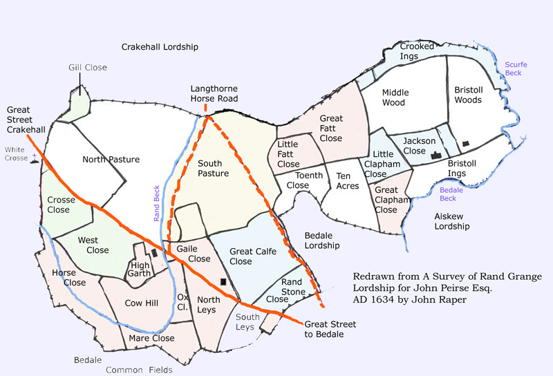
5. Rand Grange
Rand became part of the Lordship of Middleham in 1404 and was always administered with Great Crakehall, though rated as a separate township. Despite local tradition, it was never a village; there were until the 17th century three farms here, which are shown on a beautiful map made in 1634 by John Raper for John Peirse of Bedale Hall, soon after Peirse bought it from Ramsay and Heath. The earliest description of Rand is in a survey made by Aaron Rathborne, the Royal Surveyor, in 1629 that draws on a much older account describing the pasture in terms of beastgates rather than area. The tenants were allowed to graze 90 beasts in the common pasture (about 120 acres) lying north of the road to Crakehall.(see the MAP) On the southern edge of Rand was a piece of marshy pasture called Heydens or Hadnes, along the old course of the Rand Beck. The tenants also had the grazing of Burstall Wood. Most of the remaining land was meadow. The only arable was in Rand Leys, about 17 acres lying immediately south of the present farmhouse.
The farms are described in more detail in the survey of 1624, by which time the Rand Pasture was enclosed and divided into four parts, one of which was "now converted to arable and called by the name of the Rande Hill Pasture." This amounted to 34 acres. On the south side of the Bedale to Crakehall road, immediately opposite its junction with the bridle path to Kirkbridge across Rand Pasture ("Langthorne Horse Road"), was an old farmhouse and barn, with a garth, a small field called Rand Holme Close, and a larger one called Rand Close. It is shown on the Raper map as a timber-framed house, with "Low Garth" and "High Garth". It seems likely that this was the original manor house in Rand and that the house at the present site was a later one - it is shown on the 1634 map as a stone house with a chimney stack at each end. The third house, with a barn, was on the southern edge of Burstall Wood.
John Peirse of Bedale bought the whole of Rand in 1631 and immediately divided it into new fields (342 acres) to make five lettings. The unploughed part of Rand Pasture remained rough land covered with gorse and bracken until the end of the 18th century, when William Hird remembered it being cleared.
6. Improvements
The 18th century was a period of consolidation and improvement. The farms in Little Crakehall were gradually bought up by John Hutton of Clifton Castle and the Duke of Leeds at Hornby Castle. The Great Crakehall estates by the end of the century were the property of the Dodsworths of Thornton Watlass (who had 321 acres), John Hutton (336 acres) , Christopher Pickering (later James Robson, 233 acres) and Henry Mayhew (241 acres). These improving landowners built new stone farmhouses more conveniently placed in the fields - Scroggs House, Mudfield, West Pasture in Great Crakehall, the Grange and Greengates in Little Crakehall - though a few farmhouses around the village greens were rebuilt or renovated - Manor Farm, Hall Farm, Village Farm in Great Crakehall, and Mastiles and High Mill House in Little Crakehall. Cote House and Mirefall (now Mirefold), which were already in existence in 1624, were also rebuilt. The old, redundant farmhouses in the village became the cottages of labourers and tradesmen, or, were "gentrified" like Crakehall House (for Christopher Pickering), or the Malt Shovel and the houses opposite (for Lucas and Remmer). New techniques of farming were adopted. Leases of the 18th century include allowances for liming the land and later steam threshing machines became a regular feature at harvest time.
Draining the ings meadow
As farming became business, instead of simply a way of keeping the family, and business-like landlords like the Huttons and Dodsworths tried to increase rents, it was important to use every acre of land to its full potential (even in 1630 the fishing of the beck was let for 10 shillings a year). The old pastures (Low Pasture, Scroggs and Hollow Moor) had been improved by the tenants soon after enclosure. By the 18th century the only remains of the old way of farming were found in the Ings meadow. From time immemorial farmers had strips of meadow allotted to their farms in various parts of the Ings called "Dales", rather like the flatts in the arable fields. They were assigned to the farms by lottery at one time - they are described in some documents as "casts" and were marked by moveable "merkes or dowles" . Because of the heavy grazing on the pastures, the Ings were the farmers' main source of hay. In the 1624 Survey good meadow was the most valuable of all land, acre for acre. It was valued at up to 20 shillings per acre, compared with 10 shillings for arable, but the Ings meadow was only worth 6s 8d per acre, apparently because it was poorly drained and subject to unpredictable flooding.
As far back as 1450 we read of the tenants being urged to scour Scurfe Beck, which bordered and drained the Ings. This remained a constant preoccupation of the manor court through the 17th and 18th centuries. The land was drained into the Scurfe Beck by two dykes, the Ings Stell and Low Wood Stell. The problem was that when the Scurfe beck was full water actually flowed back up the stells. They were therefore embanked, but frequently overflowed. The situation was so serious that in 1773 the manor court threatened a fine of 20 shillings on any farmer who did not build up the banks of the stells in his part of the Ings. Things must have been particularly bad that winter, for on the 22nd January all the landowners concerned met at the Post House Inn in Bedale to consider a permanent solution. They all subscribed to a survey by Mr. George Jackson, a land agent and surveyor who did much work for the Earl of Holderness at Hornby Castle and was at about the same time involved in the engineering plans for the proposed Bedale Canal. He was to determine the levels of the land and streams and provide an estimate for a new drainage system. He presented this to a second meeting in July. He had discovered that the main source of the problem was not the Scurfe Beck or the stells, but the shallow meandering of Crakehall Beck downstream of its junction with the Scurfe. Drastic (and expensive) measures were needed - the Scurfe and the Crakehall Beck had to be straightened, the junction with the Scurfe altered, and the stells widened and deepened. The new course of the beck would need access bridges to Mr. Fothergill's land, which straddled the winding part of the beck. Jackson's estimate of the cost was £278-16-4 for the Scurfe and a further £71-6-9 for Crakehall Beck. This seems to have been too much for the proprietors, and the work was put off. Instead, some additional rules were announced at the Manor Court aimed at better maintenance of the existing drainage. Things obviously did not improve, and matters came to a head again in 1811. Another public meeting was called, and this time there was general agreement that improvements could not be put off. However, only a small proportion of Mr. Jackson's original proposals were put into effect - a modified straightening of the beck that cost £53 (the work took 11 weeks). It was not a great success. By 1830 the proprietors had decided to enclose the Ings and were again worried about drainage. Sir Edward Dodsworth called in a surveyor again. The surveyor wrote:
He proposed more straightening work, with the excavated earth being used for embankments, at an estimated cost of £812. He reckoned the work would improve over 500 acres of land all told, though some more internal drainage would also be needed, especially in the Ings "where there is nearly 200 acres of land without a single drain..."
The work finally undertaken is shown in a splendid map in the Beresford Pierse archives, indicating straightening of Crakehall Beck, the Scurfe and of Wassick Beck in Langthorne. The old course of the becks, and the embanked new cuts can still be clearly discerned in the fields. Though the results were very satisfactory for the farmers, William Hird recorded in his Annals of Bedale that the children of the area thoroughly disapproved. The new, fast flow of the beck ruined their favourite swimming spot in the meadows below the church in Bedale.
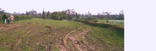
Three years later the Ings were finally enclosed by Private Act of Parliament and allotted to the landowners for their individual farms, and with this act the last vestiges of the old agriculture in Crakehall were finally obliterated. What we can see of it in the landscape today is the occasional trace of ridge and furrow, where part of the old open arable fields was grassed over in the seventeenth century and never deeply ploughed thereafter, and the banks and hedgerows that surrounded the ancient closes and lanes of the pre-enclosure fields. The old wetlands - the Sinks, the Vyvers, Powsley Carr- are drained, and the medieval woods - Low Wood, East Hagg, Burstall Wood- are felled. However, many of the old lanes through the open fields survive as roads or footpaths. On a walk along Greengates lane on a misty winter’s day it does not take much imagination to see a landscape five hundred years old or to understand why this was still regarded as a "fearsome, haunted by-way" in the 19th century (according to Edmund Bogg in his History of Richmondshire).